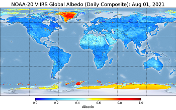
Surface Albedo (SURFALB)
Team Lead: Yunyue (Bob) Yu
Background
Surface Albedo (SURFALB), defined as the ratio between solar radiation reflected by Earth's surface and solar radiation incident at the surface, is a function of both solar illumination and the surface reflective properties. SURFALB is an essential variable linking the earth surface and the climate system. It is a unique property for studying how surface changes affect the energy balance and the overall climate system.
The first version VIIRS albedo product was generated from IDPS algorithm in the form of an environmental data record (VIIRS_EDR) since 2014 and named VIIRS Land Surface Albedo (LSA). Currently, the VIIRS SURFALB producing has been officially updated to enterprise algorithm with the release of the Level-2 (L2) Granule product and the Level-3 (L3) Gridded product. Both the L2 and L3 official VIIRS Surface Albedo products can be accessed from CLASS (Instructions) in JPSS_GRAN and JPSS_NGRN categories respectively.
The VIIRS surface albedo provides daily-mean blue-sky albedo for land surface and sea-ice. The albedo is retrieved with a direct estimation method, which directly links surface broadband albedo with VIIRS TOA reflectance through statistical modeling. Linear regression is then performed to obtain the coefficients that relate albedo to TOA reflectance. The regression coefficients are stored in a LUT, indexed by viewing geometry, latitude, and the declination angle. Details of the algorithm is introduced in the ATBD, (PDF, 2.64 MB). The products have reached validated maturity and the errors of the current SURFALB retrievals are well smaller than L1RD threshold. The validation result of the SURFALD albedo with ground measurements is displayed and routinely updated in the Land Team LTM webpage.
Algorithm Science and Data Access
Products and data:
- L2 VIIRS Albedo (SURFALB) at CLASS (start from 9/20/2019)
- L3 VIIRS Albedo at CLASS (start from 8/20/2020)
- IDPS LSA: VIIRS Surface Albedo EDR (VISAO) (public 11/21/2014 - 06/24/2020)
- CLASS FTP (last 90 days of available data) - FTP site - FTP site
EDR Long Term-Monitoring
Documentation
- L2 Albedo ATBD, (PDF, 2.64 MB)
- L3 Albedo (with LST) ATBD, (PDF, 3.36 MB)
Users
Scientists and modelers in many fields may need the SURFALB data, including NOAA NWS Environmental Modeling Center, USDA Agricultural Research Services, USDA Forest Service, STAR, and NCDC as well as universities and other research institutions throughout the world.
Calibration and Validation
The team has collected ground albedo measurements from various monitoring networks across the world for the validation of VIIRS albedo products. The surface stations, including AmeriFlux, BSRN, GC-Net, SURFRAD, and PROMICE, were used to validate their performance. The validation results from the selected spatially representative sites suggested that VIIRS albedo can meet the L1RD requirement and have comparable accuracy with MODIS albedo product (Wang et al., 2013, 2016; Peng et al., 2018; Zhou et al., 2016).
Ongoing Improvements
Although the VIIRS SURFALB has passed criteria of the validated V1 release, the team is still working hard on some critical improvements. First, comprehensive validation is ongoing to monitor the product performance over worldwide representative ground stations and the result is continuously updated in the land team monitoring webpage. Second, the team has been committed to promote LSA applications including albedo climatology development and albedo product implementation in climate models.
Publications
Peng, J. J., Yu, Y. Y., Yu, P., & Liang, S. L. (2018). The VIIRS Sea-Ice Albedo Product Generation and Preliminary Validation. Remote Sensing, 10(11). [10.3390/rs10111826]
Wang, D. D., Liang, S. L., Zhou, Y., He, T., & Yu, Y. Y. (2017). A New Method for Retrieving Daily Land Surface Albedo from VIIRS Data. IEEE Transactions on Geoscience and Remote Sensing, 55(3), 1765-1775. [10.1109/tgrs.2016.2632624]
Zhou, Y., Wang, D., Liang, S., Yu, Y., & He, T. (2016). Assessment of the Suomi NPP VIIRS Land Surface Albedo Data Using Station Measurements and High-Resolution Albedo Maps. Remote Sensing, 8(2). [10.3390/rs8020137]
Wang, D. D., Liang, S. L., He, T., & Yu, Y. Y. (2013). Direct Estimation of Land Surface Albedo from VIIRS Data: Algorithm Improvement and Preliminary Validation. Journal of Geophysical Research-Atmospheres, 118(22), 12577-12586. [10.1002/2013jd020417]

