MiRS System
Team Lead:
Mark Liu, Christopher Grassotti
Product Description
Microwave Integrated Retrieval System (MiRS):
- Enterprise Algorithm System applied to a number of microwave sensors:
Operational: POES (N18/N19), Metop-A and Metop-B (AMSU/MHS), DMSP (F16/F17/F18/F19), Megha-Tropiques (SAPHIR), GPM (GMI), and SNPP/JPSS (ATMS)
Experimental: TRMM (TMI), Aqua (AMSRE), and GCOM-W (AMSR2) - Same executable, forward operator, and covariance matrix for all sensors
- Modular design makes it feasible to run on other MW sensors or in combination with collocated IR measurements
Product and Data Access
Products and data:
- OSPO NDE
- OSPO FTP - FTP site
- CLASS
- CLASS FTP (last 90 days of available data) - FTP site
- MiRS Team Site
EDR Long Term-Monitoring
Documentation
- MiRS ATBD, (PDF, 1.38 MB)
Retrieval Output EDRs:
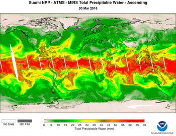
Atmospheric Temperature Profile, Atmospheric Water Vapor Profile, Total Precipitable Water, Land Surface Temperature, Surface Emissivity Spectrum, Sea-Ice Concentration, Snow Cover Extent, Snow-Water Equivalent, Integrated Cloud Liquid Water, Integrated Ice Water Path, Integrated Rain Water Path, Rainfall Rate.
Added MiRS V11.1: Snowfall Rate, Sea Ice Age, Snow Grain Size
Users
Cooperative Institute for Research in the Atmosphere (CIRA): Hurricane Intensity Analyses/Forecasts; Morphed Integrated Microwave Imagery at CIMSS (MIMIC): TPW Animations; Climate Prediction Center (CPC): Precipitation, Blended TPW; Community Satellite Processing Package (CSPP): Direct Broadcast
Future Improvements
- Snow (vegetation correction)
- Rainy condition sounding (update a priori constraints)
- Hydrometeors (improvements to CRTM i.e. scattering, precharacterization of precip type, particle size/shape distribution in CRTM, CLW over land for light rain detection)
- Air mass-dependent bias corrections

