 Branch/
Laboratory for Satellite Altimetry")
Ocean Topography and Cryosphere (OTC) Branch/
Laboratory for Satellite Altimetry (LSA)
Projects
The LSA specializes in the application of satellite altimetry to a broad array of climate and weather related issues, including global and regional sea level rise, coastal and open-ocean circulation, weather prediction — from hurricane intensity forecasting to El Niño and La Niña events -- and monitoring the changing state of the Arctic Ocean. The following are some primary areas of focus:

Sea Level Rise
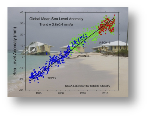
The Jason global mean record shows sea level rising at about 3 mm/year, nearly twice as fast as during the last century. Research into the causes of sea level rise, through the addition of ice melt water, ocean warming (thermal expansion), and changes in ocean circulation is a major Lab activity.

Ocean Bottom Topography
Seamounts, mid-ocean ridges, trenches — all of these marine geophysical features modify local gravity in ways that cause variations in mean local sea level. The LSA, in collaboration with Scripps Institution of Oceanography, pioneered the use of satellite altimeter observations of these sea level "signatures" to determine the first truly global map of ocean bottom topography.
Jason Altimeter Program
With the planned launch of Jason-3 in 2015, NOAA and its operational European partner, EUMETSAT, will assume primary responsibility for maintaining the more than 22-year TOPEX/Jason series of high accuracy, global sea level observations used to monitor ocean circulation and sea level rise. The LSA is the science focal point for the Jason Program within NOAA.
Arctic Sea Ice
The Arctic has been experiencing tremendous change over the past decade, including historic declines in sea ice thickness and extent. The LSA Sea Ice Team is using data from CryoSat-2 and other altimeter missions to observe seasonal changes in sea ice thickness, with the goal of using this information in sea ice prediction models.
