|
Data and images displayed on STAR's sites are provided for experimental use only and are not official operational NOAA products. More information>> |
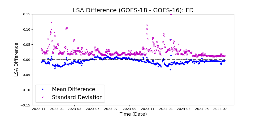
Inter-sensor LSA ComparisonNOAA's operational GOES-East (GOES-16) and GOES-West (GOES-18) are observing the earth from 75º W and 137º W, respectively. Besides, GOES-Test (GOES-19) is currently deployed at 89.5º W. Despite their different locations and viewing geometry, they share common spatial coverage at land mainly in North America. In order to monitor the Advanced Baseline Imager (ABI) land products' performance and study the difference between these two platforms, their co-located retrievals in a region of interest (ROI) between 30º N and 40º N, and between 90º W and 100º W are routinely compared. The ROI is selected to minimize the uncertainty from terrain caused parallax effect and view zenith angle difference. Given the difference in their viewing geometry, a reprojection of the product from one satellite to the other is applied before the comparison region is subset to achieve an accurate geolocation match. The mean and the standard deviation of their difference are then assessed and demonstrated in the following figure(s).  Two indices are provided:
Note: Land surface albedo is a daytime product available under SZA<70°. Matchups at UTC hour 19 are used to for the comparison. All LSA retrievals at this hour with retrieval path of 0 count as qualified retrievals. For users interested in difference between GOES-18 and GOES-17, please refer to their historical comparison results before the latter was put on storage. |
|
|
|